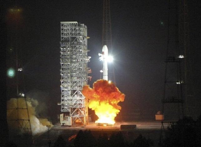
A Long March 3C, carrying the sixth Beidou navigational satellite, lifts off from the Xichang Satellite Launch Center, Sichuan Province, in 2010. (Photo : REUTERS)
China launched on Monday, Feb. 1, at exactly 3:29 p.m., a key satellite to support its global navigation and positioning network, the Xinhua News Agency reported.
According to the report, the satellite was launched from the Xichang satellite launch center in the southwestern province of Sichuan, aboard a Long March-3C carrier rocket. It is the 21st satellite in the Beidou Navigation Satellite System, as China moves closer to providing an alternative to the United States' GPS system.
The report said that the first 16 Beidou satellites were launched for a network that only covered China and nearby regions, while the first new-generation satellite in the series, or the 17th, launched in March last year, will help in the network transition from regional to global coverage.
The latest satellite launched on Monday, which is the fifth of the new generation, will join the four predecessors in testing intersatellite crosslinks and a new navigation-signaling system that will set the framework and technical standards for global coverage.
Xiang Libin, commander-in-chief of the Beidou project, said that the latest satellite is critical to the integration of the two signal systems for regional and global navigation and the switching between the two.
"Our new intersatellite crosslink system, featuring strong disturbance resistance and high-level privacy, is the core technology to compete with other countries' navigation networks. The new satellite will fully verify our technology," Lin Baojun, the satellite's chief designer, said.
Lin added that the satellite will continuously operate without ground control and broadcast assistance, which are key requirements for navigation services.
As the satellite is designed for medium Earth orbit, it will fly at an altitude of around 20,000 kilometers to detect high energy particles, which are abundant in the orbit and risky for satellite components and functions, as well as enable the Beidou project to avoid interference from these particles.
Li Guotong, deputy commander-in-chief, added that the the satellite carries a China-made chip that will help in the design of smaller, better integrated, more reliable satellites.
The Beidou project began in 1994, some 20 years after GPS. The first Beidou satellite was launched in 2012, when a regional network was formed, providing positioning, navigation, timing and short message services for China and several other Asian countries.
The country plans to expand the Beidou services to other countries covered in its "Belt and Road" initiative by 2018, and will offer global coverage by 2020, the report said.


