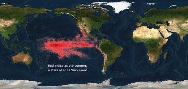
Federal forecasters from the National Oceanic and Atmospheric Administration (NOAA) predicted that there is more than 90 percent chance that El Niño will be here to stay for the whole duration of the coming winter, and another likelihood (85 percent) that it won't be leaving up until springtime in 2016.
And that's not all, experts claim, based on the most recent ocean and atmospheric data, that this climatic condition could go head-to-head with the strongest of its kind as sea surface temperature continue to surge in major parts of the Pacific Ocean.
This El Niño event could give California the much needed rainfall it so desperately yearn for as it continuously suffer from the current record-breaking drought. The state has been ravaged by incidents of wildfires, and a wetter-than-usual weather will be a welcome respite.
But even if this El Niño would shape up to be the strongest in history, the experts were quick to admit that it won't suffice to provide enough rainfall in California amid the prolonged dry spell, according to The Guardian.
"We would need something in excess of the wettest year on record to balance that deficit," said Kevin Werner, the director of western region climate services at NOAA. "One season of above normal rain and snow is very unlikely to erase four years of drought."
El Niño is a periodic climate condition, occurring every two to seven years, wherein temperature rises across the equatorial Pacific Ocean, and could cause weather disturbance from different parts of the globe.
The two most dreadful and devastating El Niño events in recent memory happened back from 1982 to1983 and in 1997, the Mashable wrote. The effects of this climate disturbance vary from different geographical locations. It could bring about torrential rains and flooding in some areas while others could experience drought and dry climate.


