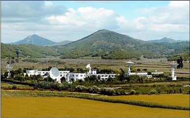
The Miyun Satellite Data Receiving Station, put into operation in 1986, covers the eastern, central, and northeastern regions of China and some neighboring regions of other countries. (Photo : ww.english.radi.cas.cn)
China is set to begin operation of the first overseas satellite data receiving station which will be established in Sweden.
The Chinese Academy of Sciences, Institute of Remote Sensing and Digital Earth Institute said that the station will be China's fourth of its kind and the first station to be built outside China. The other three are all located in China.
The government said that the data receiving station will start its operation in the next two years and will gather information covering Europe and the Arctic region.
According to experts, the station will allow China to receive data gathered remotely by satellite that the country can use for its research on environmental conditions, global climate change and distribution of resources.
Qin Qiming, professor at the Institute of Remote Sensing at Peking University, said that the information obtained from the North Pole station will be compared with the data from China's remote sensing satellite.
"By using observation information from outside China, we can compare this data with the resource and environment data that is gathered within the country. In this way, we can monitor changes in China's environment. This could help China to take targeted measures to prevent disasters and conduct relevant research and evaluations," the professor was quoted as saying.
At present, China has three satellite data receiving stations for domestic use which are located in Xinjiang, Beijing and Hainan Province. The three stations provide satellite data on the country's total land and water territory, including 70 percent of all Asian territory.
The data obtained by satellite on the Earth's surface often show observations that can be used in many fields of research, especially on disaster, resources, environment, agriculture, ecology, and biodiversity, among others.


