The AuthaGraph World Map. (Photo : Hajime Narukawa)
A new and award winning map of the world is more accurate and far less distorted than the 2-D maps commonly in use today, and presents a clearer picture of the Earth as it really is.
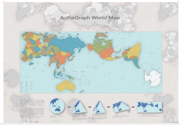
The "AuthaGraph World Map" invented by Japanese architect Hajime Narukawa in 1999 is based on the Authagraph projection, an approximately equal-area world map projection.
The AuthaGraph World Map is made by equally dividing a spherical surface such as the Earth into 96 triangles, transferring it to a tetrahedron while maintaining area proportions, and unfolding it onto a rectangle.
The map substantially preserves sizes and shapes of all continents and oceans while reducing distortions of their shapes that occur in maps based on the widely used Mercator projection.
Invented 450 years ago to make it easier for mariners to plot routes over long distances, Mercator projection maps are notorious for the enormous distortions they create.
Greenland is made to appear larger than Australia when it's actually 3.5 times smaller than Australia, for example. Antarctica looks like the biggest continent on Earth when it's only the fifth largest.
The AuthaGraph World Map remedies these distortions and is considerably more accurate than traditional 2-D maps. It's basically a globe broken down into a 2-D map.
"This original mapping method can transfer a spherical surface to a rectangular surface such as a map of the world while maintaining correctly proportions in areas," according to a description of the new map.
"AuthaGraph faithfully represents all oceans, continents including the neglected Antarctica. These fit within a rectangular frame with no interruptions."
The AuthaGraph can also be tessellated, meaning that multiple versions of the map can be laid next to each other with "no visible seams," enabling tricks like tracking the orbit of the International Space Station in 2-D.
From this map-tiling, a new world map with triangular, rectangular or a parallelogram's outline can be framed with various regions at its center.
In October 2016, the Authagraph mapping projection won the 2016 Good Design Grand Award from the Japan Institute of Design Promotion.
In 2011, it was selected by the Japanese National Museum of Emerging Science and innovation (Miraikan) as its official mapping tool. And in 2015, it began being used in official Japanese high school text books.


