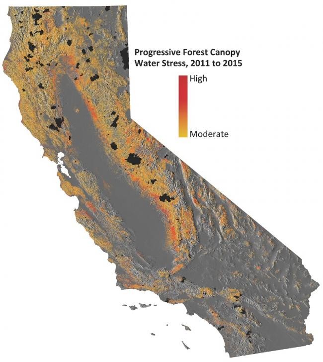
Progressive forest canopy water stress in the state of California from 2011 to 2015. (Photo : Greg Asner/Carnegie Science)
New satellite data reveal the severe impacts of California's drought on trees that has been ravaging the region since 2011.
Scientists from have Carnegie Institution for Science's Airborne Observatory utilized new laser imaging tools along with satellite data that reveals the devastating impacts of this ongoing drought. Almost 888 million trees have already experienced stresses from this drought where 58 million of them have already reached dangerous water loss, according to new research.
This means that California's massive trees are at huge risk of dying, by catching fire or deadly infestation of bark beetles.
According to Greg Asner from Carnegie, the state relies on its forests not only for water supply and carbon storage but also for timber, tourism and recreation which are not only important for California's ecosystems but also for the state's economy and cultural advancement. However, this drought is now putting the forests in peril, as this event can cause long term changes that can damage the ecosystems, impacting animal habitats and also biodiversity.
Using these tools, this helped the team to gain measurements of the full impact of this California drought on the region's forests and even predict which trees are at the greatest risk of death and catching fire. Researchers still believe that even if there is more rainfall brought about by the El Nino phenomenon, they estimated that drought conditions can still return in the near future due to the vulnerable and fragile state of the forests, leading to catastrophic changes.
According to California Environmental Protection Agency's deputy secretary fro climate policy, Ashley Conrad-Saydah, this new data obtained from Carnegie Airborne Observatory's research can now provide invaluable insight about how severe these drought impacts are, in order for the state to face the challenges of this epidemic of dying trees and hopefully, to aid in the recovery of California's forests.
Asner also adds that this high resolution forest mapping can now identify vulnerable trees and changing landscapes. Airborne and satellite monitoring will still continue to mitigate these negative impacts of forest drought and also to aid in recovery when the drought subsides.
This new study is published in the Proceedings of the National Academy of Sciences.


