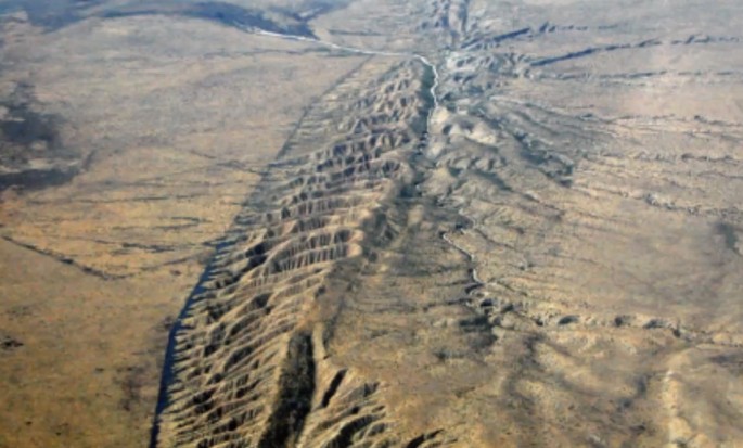
Bird's eye view of San Andreas Fault in California (Photo : YouTube Screenshot/MlordandGod)
The San Andreas Fault which is the longest earthquake fault in California remains one of the most dangerous. A computer image was produced by some scientists showing the land around the San Andreas Fault rising and sinking which is believed to be caused by seismic strain.
As posted by SFGate, scientists have been expecting this for a long time that those lands surrounding the San Andreas Fault will slowly move over time. What makes it dangerous for the California State is it sits on the border of the fault and when the time comes that those faults move, a big destruction will likely occur due to earthquakes.
According to those scientists who posted this study in the Journal Nature Geoscience, a large area in San Bernardino County, Santa Barbara and San Luis Obispo Counties are rising 2 - 3 millimeters every year while the lands that are sinking at the same rate every year are found in San Diego County, Orange County, Lost Angeles Basin, and the area in Bakersfield.
The San Andreas Fault has not move significantly in more than 150 years which is located in between Imperial County and Monterey County. The lead author of the report, Sam Howell, a doctoral candidate in Geophysics at the University of Hawaii said, "Once there is a major event, all of that energy gets released."
The last recorded large earthquake that struck in San Andreas Fault was in 1857 where it torn a large part of land from Monterey County to Los Angeles County. It was a 7.9 magnitude earthquake that devastated a big area in state.
Basing on the past data, the big earthquakes happen in every 150 years on average but this is still not a guarantee since it may vary over time. However, Howell emphasized that this study is not going to help them directly on how to know when the next big earthquake hit because it is truly unpredictable.
Scientists may find it easy on how to see the whole state move from different directions horizontally but it is quite a challenge for them to see it vertically because it includes many factors. Examples are the change of water levels and flushing out of deep ground water which causes the land to sink.
The breakthrough that was done by the scientists involved in this study generated a computer code that can identify the real cause of the rising and sinking of land. The computer can tell if it is caused by seismic activities or other factors.
Here's a short video about San Andreas Fault predictions.


